A guide for Trekking to Everest Base Camp
Trekking to Everest Base Camp in Nepal is undoubtedly a dream for anyone who loves mountains and trekking. For some, it’s a true Mecca.
There are several options to complete this beautiful experience, from the classic flight to Lukla to less traveled starting points where flying isn’t necessary, such as Salleri/Phaplu and Jiri. In this guide, you’ll find all the relevant information, including all the variations such as the Three Passes trek and Island Peak.
I personally completed the trek (you can find the video of the trek here, in Italian, but you can turn on the subtitles) without a guide or porters, together with my no-longer-so-young dad and completely self-sufficient. In this blog, you’ll find all the information and advice you need to best organize your DIY trip to Nepal and complete the trek to Everest Base Camp.
Quick menu
- How to get to Everest Base Camp
- Everest Base Camp or Annapurna Circuit
- Permits and visas
- When to go
- Difficulty and preparation
- Everest Base Camp trekking routes
- What to bring
- Guide, porter or DIY
- Food and accommodation
- Trekking costs
- Safety along the trails
- Where to sleep in Kathmandu

Sunrise at Chukhung Ri.
In this guide, prices are expressed in the local currency called “Nepalese Rupee” often abbreviated simply as “NPR.” The exchange rate is about 1€ = 170 NPR. For the current exchange rate, I suggest you look at this page.
How to get to Everest Base Camp (the various routes and possible variations)
Before we begin, here’s a map that will hopefully shed some light on what the options are for reaching Everest Base Camp and the possible variations described in this guide.

Basically, here are the four main alternatives:

Everest Base Camp or the Annapurna Circuit?
If you’re reading this article, you’ve probably already made up your mind. However, in case you’re still debating what to do, I want to share a few words about what, for many, is a tough choice when you have perhaps only two weeks to trek in Nepal: Annapurna Circuit or Everest Base Camp?
First of all, they’re both beautiful treks, but if I really have to express my preference, I’d opt for the Circuit as the scenery is much more varied. You start from an almost tropical climate all the way up to the 5416 meters of the Thorong La pass. Plus, being a circuit, each day is different, and you don’t have to follow the same trail up and down.
Two other things that make me lean toward the Circuit are the fact that it’s far less busy/popular than the Everest Base Camp trek. To use Dad’s expression after we ran into a real traffic jam near a suspension bridge: “It’s like being on the trail to the Tre Cime di Lavaredo!” And our experience was in the spring; I don’t dare imagine what the situation is like in the fall.
Another reason I’d recommend the Circuit is the cost. Food and lodging are, on average, 30% cheaper than Everest Base Camp. Especially if you decide to complete the latter with a flight to Lukla (a practically forced choice if you only have two weeks to spare), then the Circuit will cost you practically half as much as Everest Base Camp.
Taking all this into consideration, Everest Base Camp still has its appeal, and the final choice is obviously up to you. What has been said so far is merely my humble opinion.
In case you’re interested, you can check out my guide to the Annapurna Circuit, Annapurna Base Camp and Poon Hill.

Trekking from Phaplu to Nunthala.
Permits and visas needed to trek and enter Nepal
Let’s start with the visa to enter the country. The visa is mandatory, but fortunately, holders of an Italian passport (valid for more than 6 months) receive a visa called Visa On Arrival (VOA) the moment they enter the country (the rules change depending on your nationality, so check yours). The process is extremely simple and straightforward, but unfortunately, it isn’t free.
There are three options:
15 days – 30 USD.
30 days – 50 USD.
90 days – 125 USD.
The visa can easily be extended to a maximum of 150 days per calendar year (January 1-December 31), although it isn’t exactly cheap. You can find the costs here; it’s probably better to leave and re-enter the country with a new visa. In any case, with a tourist visa, you can’t stay in the country for more than 150 days per calendar year.
Two passport photos (passport-size) are also officially required to complete the visa process once you arrive at the airport/land border. However, if you complete the form online (it stays in the system for 15 days, so don’t do it too far in advance), they aren’t needed and you’ll most likely save quite a bit of time upon arrival, especially at the Kathmandu airport where you can head straight to immigration without standing there filling out the form. I recommend doing it.
The visa at Tribhuvan airport can theoretically be paid by credit card, but in practice, from what I’ve read, it depends on the day! I tried and was told it wasn’t possible. In any case, all major currencies (including euros) are accepted. To avoid unfavorable exchange rates, ideally, you should pay in U.S. dollars, but I wouldn’t worry about it too much unless you already have them.
As for land borders (find the full list here) apparently only U.S. dollars are accepted, so adjust accordingly.
Nepal doesn’t require any mandatory vaccinations but Hepatitis A and B are recommended.

Trekking from Bupsa to Surke.
Permits for trekking to Everest Base Camp
N.b. TIMS (Trekker’s Information Management System) which is required to complete many treks in Nepal is no longer required for the Everest region as of 2018, be wary of those who say otherwise.
Two / three permits are required to reach Everest Base Camp depending on the starting point chosen:
Khumbu Pasang Lhamu Rural Municipality Entry Permit
This is a new permit that, since October 2018, essentially replaces the TIMS. It’s a fee that goes to the local Khumbu government. The permit can be obtained in Lukla, or in Monjo if you decide to start your trek in Jiri or Salleri. It isn’t possible to obtain the permit in Kathmandu.
The cost is 3000 rupees, about 25€.
Sagarmatha National Park Entry Permit
As you may have guessed this is the permit to enter Sagarmatha National Park. It can be obtained at the Kathmandu Tourism Board which is about 2 km from the main tourist area of Thamel (you can easily walk). The office is open from 10:00 to 17:00.
Alternatively, as many do, you can get it directly in Monjo where the entrance to the national park is located.
The cost is 3000 rupees, about 25€.
Gaurishankar Conservation Area
You only need this permit if you decide to complete the trek to base camp starting from Jiri. The permit must be obtained at the Kathmandu Tourism Board.
The cost is 3000 rupees, about 25€.
N.B. Unfortunately, as of April 1, 2023, it’s no longer possible to complete many treks in Nepal without being accompanied by a guide. I think it’s a real disgrace, yet another decision driven by greed disguised as “safety issues.” I hope the Nepalese government reconsiders this decision in the future, but for now, this is the reality. Fortunately, as I understand it, the issue arises when obtaining the TIMS (Trekker’s Information Management System), which isn’t necessary to complete the trek to Everest Base Camp, so it seems the Everest region has been spared for now, as you can read here: https://explorersweb.com/solo-trekking-banned-nepal/.

Sunrise from Kala Patthar.
When to go? Weather, temperatures and best time
Spring (March, April, and May)
This period precedes the monsoons that characterize the summer months (June, July, and August). Early in the season, there may be occasional snowfall, but the weather is generally stable and dry, ideal for high-altitude trekking.
March, although colder, is preferable to April and May for those wanting to avoid crowds. April and May, with milder temperatures, bring a much busier and more fascinating base camp. Late May, just before the monsoons, is the most favorable time to attempt the summit ascent. Outside of April and May, the base camp is essentially an expanse of ice.
Summer (June, July, and August)
Rain, rain, and more rain. This is the monsoon season, and it’s absolutely not a recommended time for trekking. I met a group of French guys who told me about a friend of theirs who completed the route in June by starting each day at 5 a.m. to avoid the rain. Apparently, it worked.
In any case, it’s certainly not ideal, as the views would almost certainly suffer. July and August are even rainier, so I really don’t think it’s worth venturing out.
If you want to trek during this time, the Annapurna Circuit is definitely a better alternative.
Fall (September, October, and November)
This is considered the best season in terms of weather. The rain of the summer months clears the haze, and the views are considered the best of the year. Beware of September, which may still be relatively rainy depending on the year.
In general, it’s slightly colder than spring but still the best time to trek and also the most crowded. At high altitudes, lodges can be extremely crowded, especially during October, which sees the peak of tourists in the region.
Winter (December, January, and February)
It’s definitely possible to trek, but at high altitudes, it can get really cold with temperatures dropping to as low as -30 degrees overnight. Days are short, and there may be significant snowfall, resulting in some passes being closed (generally not the traditional trail to base camp).
If the cold and snow don’t deter you, this might be a good time to trek the region and avoid the crowds. Just make sure you have the right equipment!

The village of Cheplung.
Difficulty and preparation for the Everest Base Camp trek
The trek is certainly not a walk in the woods. The altitude, especially near the base camp, definitely takes its toll, but anyone in decent shape can complete the trek.
To give an objective fact: I completed the trek with my dad, who, although definitely more fit than most of his peers, is still 63 years old and certainly doesn’t have the recovery time of much younger people. Not to mention, we started from Phaplu, adding six days of not exactly easy trekking compared to starting from Lukla, and we had no porters.
So if you decide to start from Lukla and perhaps hire a porter, the trek becomes accessible to many. That said, I recommend taking the preparation seriously. In the months leading up to the trek, try to go walking at least a couple of times a week for 4-5 hours at a time to simulate a typical day on the trail. Ideally, you should also load your backpack properly, perhaps with the same weight you’ll carry during the trek. More information and tips on managing altitude can be found later in the guide.
The Three Passes Trek, on the other hand, is definitely harder than the Everest Base Camp Trek. However, if you’re in good shape, it shouldn’t be a problem at all.

Sunset in Thame.
The trekking routes to Everest Base Camp
As seen above, there are basically three routes to Everest Base Camp. I’ll start by describing the classic route from Lukla in detail. For the other two itineraries starting from Jiri and Salleri, I’ll describe only the section up to Lukla in detail, as once you reach Lukla, the route is the same.
Finally, there’s the Three Passes Trek, which technically doesn’t include a visit to Everest Base Camp, but in practice many trekkers include this short detour once they arrive in Lobuche.

The following itinerary is designed so that you walk only in the morning to early afternoon (with some rare exceptions) for a total of 5-6 hours per day and have lunch only once you arrive at your destination. Generally, departure is around 7:00/7:30 and arrival around 13:00/14:00 at the latest. We’re probably slightly faster than the average person, so if after the first few days the schedule doesn’t add up, adjust accordingly.
There are at least three good reasons to adopt this strategy:
- Throughout the year, the weather is generally better in the morning, so better views and lower chances of rain.
- Avoiding the break: it doesn’t break your rhythm, and above all, you avoid walking on a full stomach, with the resulting diversion of blood to the digestive system, which, especially at high altitude, is a terrible idea. Once you arrive at your destination, you’ll have all the time you need to relax and recover.
- Arriving at your destination and then having lunch will often save you the cost of the room. 99% of lodges, especially at low altitude, are more than willing to offer the room for free in exchange for the three meals. However, if you stop to eat on the way, the meals become two, and the lodge may be more reluctant to give you the room for free.
Another thing to remember is that you can actually stop almost anywhere along the way. Especially at low altitudes, the villages are all a short distance from each other, and the recommended stops can easily be swapped for the next village. Plus, there are really a lot of lodges/tea houses between one village and the next, giving you basically endless possibilities to stop if you’re tired or simply want to keep walking a little longer after reaching your designated destination.
Finally, I recommend downloading Organic Maps: the app works offline once you’ve downloaded the maps, and I think it’s a fantastic tool for completing treks.
Trekking itinerary to Everest Base Camp starting from Lukla in 12 days
This is the shortest version of the trek. The only faster way to reach base camp is by helicopter. Despite being the shortest version of the three itineraries, it’s also the most expensive, as the round-trip flight from Kathmandu to Lukla alone costs over $300 for not even 30 minutes of flight, and tickets can be purchased on the Yeti Airlines website.
Considering that the cost of the entire trek—starting from Salleri and making some variations from the shorter version for a total of 20 days—was about 370€ each, if you have the time and the will, with just the money you’d spend on the flight to Lukla, you could easily finance the entire trek.
I understand that for some people, time is a significant factor and money takes a back seat. So, here’s the itinerary starting from Lukla.

The village of Pangboche.
Day 1. Flight Kathmandu – Lukla (about 30 minutes) / Hiking Lukla – Phakding (4 hours, 8 km)
Lukla (2860m) – Phakding (2610m)
I strongly recommend taking the flight early in the morning so that you have the whole day ahead of you, especially considering potential delays, which are apparently frequent. The flight has been described to me as extremely scenic, so enjoy the scenery.
Upon arriving in Lukla, you’ll find a very manageable stretch to Phakding ahead of you, mostly flat or even slightly downhill.
Day 2. Phakding – Namche Bazar (6 – 7 hours, 10 km)
Phakding (2610m) – Monjo (2835m) – Namche Bazar (3440m)
Again, I recommend leaving early to avoid the queue that forms at the entrance to the national park in Monjo. Arriving mid-morning from further down the valley, we waited in line for 40 minutes to buy the tickets.
In any case, the section from Phakding to Monjo is very manageable and similar to the previous day. However, once you reach Monjo and enter the national park, an endless climb begins that practically never lets up until Namche Bazar.
It’s only a 5 km ascent, but the recommended hiking time is 6 hours, which is probably exaggerated. We were already acclimatized from the Annapurna Circuit, and we made it up in less than 3 hours. Nonetheless, it’s still a challenging stretch, and the altitude at this point begins to affect many trekkers.
N.B. If you didn’t purchase your Khumbu Pasang Lhamu Rural Municipality Entry Permit in Lukla, you must do so in Monjo. The small office is located before the entrance to the national park. In any case, don’t worry, because you’ll certainly be asked to show, or if necessary buy, the permit. We didn’t have to wait in line here because most people already had the permit, most likely obtained in Lukla.

Sunrise in Namche Bazar.
Day 3. Namche Bazar (Rest day / acclimatization)
We skipped this day because, as just mentioned, we were already acclimatized from the Annapurna circuit. If that’s not your case, it’s absolutely advisable to spend the day in Namche Bazar to give your body a chance to adjust to the altitude.
It’s also advisable to keep active anyway, perhaps by climbing up to one of the many viewpoints surrounding the town. If you’re missing a few pieces of equipment or maybe want to treat yourself by eating something other than the typical local food, this is the ideal place to do so: more than a village, it’s in fact a real town with restaurants, bars, wifi, stores, ATMs, etc.
Accommodation is also plentiful here, including excellent hotels such as Hotel Khangri, but if, like us, you’re traveling on a budget, I recommend this lodge: in exchange for meals, the family, who by the way are really nice, is willing to give you the room, wifi and shower (cold, but if you want you can pay and get it hot) for free. I assure you that in Namche this is a real bargain.
Day 4. Namche Bazar – Tengboche (4 – 6 hours, 8km)
Namche Bazar (3440m) – Tengboche (3870m)
Leaving Namche, the first few kilometers are really pleasant and extremely easy, mostly flat. After about two hours, you reach a checkpoint at the bottom of the valley. From here, a steady climb begins towards Tengboche, gaining 600 meters in elevation. The altitude makes this climb challenging, but once you reach the top, the day’s trekking ends.
In Tengboche, there’s also a Buddhist monastery that you can visit, and it’s very interesting to discover. A little curiosity: the famous Tenzing Norgay grew up in the nearby village of Thame. For those unfamiliar, Tenzing Norgay was the Sherpa who, along with Edmund Hillary, first reached the summit of Everest in 1953.

Tengboche Monastery.
Day 5. Tengboche – Dingboche (4 – 6 hours, 10km)
Tengboche (3870m) – Pangboche (3930m) – Dingboche (4360m)
The day begins with a downhill stretch, but then the trail steadily ascends. During this section, the trees start to thin out, and the vegetation reduces to shrubs, exposing you to the sun the whole way. The views start to get really interesting.
N.B. During the high season, roughly April, May, September, and October, once you reach this point, I strongly recommend booking your lodging at least the day before. From here on, there aren’t many lodges and the stops are practically fixed, so the risk of not finding a room and having to spend the night in the dining hall at Lobuche and Gorak Shep is really high. To book, simply ask the lodge where you’re staying to make a call—they all know each other and know what to do.
Day 6. Dingboche (Rest day / acclimatization)
Again, we skipped this day altogether because we were already acclimatized from the Annapurna Circuit, but if that’s not your case, it’s advisable to spend the day in Dingboche to allow your body to adjust to the altitude. If you feel extremely well, you could move on to day 7, but this is absolutely subjective: listen to your body.
Possible variant towards Chukhung
If you have two extra days available, there’s a really interesting variation I recommend. If you don’t have altitude issues, on this day (or even the previous day), you could hike up to Chukhung, basically following the Three Passes Trek route. The next morning, you can climb up Chukhung Ri and return to Dingboche or Pheriche along the same trail. It’s not necessary to reach the summit of Chukhung Ri (which is over 5500m). The first viewpoint at 5375m offers a spectacular enough panorama and was undoubtedly one of the highlights of the entire trek.
We were already acclimatized and made the ascent in a little over an hour and a half, starting around 4:30 from the lodge in Chukhung, but otherwise it would probably have taken us at least two hours. Doing it at sunrise is definitely nicer, but you can easily do it during the day too.
The lodges in Chukhung operate as a cartel: 500 rupees for a double room, no discussion, so you might as well choose the best one. Khangri Resort is the best of the bunch. If you want to extend the detour even further, from Chukhung you can also decide to visit the Island Peak base camp as a day trip.

View from Chukhung Ri.
Day 7. Dingboche – Lobuche (4 – 6 hours, 7km)
Dingboche (4360m) – Lobuche (4940m)
The day begins with a pleasant, gently rising false flat through a beautiful valley until you cross a small stream. Just above is a small lodge serving as a refreshment point. From there, a nice climb of about 300 meters leads to a beautiful viewpoint with a memorial overlooking the entire valley.
After this ascent, the trail flattens out and is similar to the gentle slope earlier, leading to the small village of Lobuche. We stayed at Mother Heart Lodge, where our room had been booked two days earlier by the lodge in Chukhung, so we had no choice, but I think there are better options. The New EBC Guesthouse seems to be by far the best option, but apparently the agencies book it out many days in advance. In any case, the lodges here operate as a cartel too: 700 rupees for a double room.
N.B. There’s a really interesting alternative here for those who don’t have budget issues, and above all a source of pride for us Italians. About 1.5 km from the village of Lobuche towards Gorak Shep, there’s an Italian research center known as “La Piramide” where you can spend the night. I talked to two people who did it, and they told me the facility is really nice. It costs about $50, with all meals and a hot shower included. If you’re looking for a bit of comfort at high altitude, this could be a good option for you.

The village of Lobuche.
Day 8. Lobuche – Gorak Shep – Everest Base Camp – Gorak Shep (5 – 8 hours, 15 km)
Lobuche (4940m) – Gorak Shep (5160m) – Everest Base Camp (5364m)
This is the day you finally arrive at Everest Base Camp. The first section is in line with the end of the previous day and continues on the valley floor, but after a couple of kilometers a really annoying up and down begins, which, combined with the really uneven rocky terrain and the funnel effect that is created here, can take quite a while.
We left early and took just under two hours to get to Gorak Shep but again, we were already acclimatized so I think 3-4 hours is more reasonable. Upon arriving at Gorak Shep, leave your backpack at the lodge (or at least empty it of what you don’t need) and proceed to Everest Base Camp, the earlier you leave the better so as to avoid possible afternoon clouds.
From Gorak Shep to base camp is about 1-2 hours. There are no major climbs but the route is along the lines of the section before arriving at Gorak Shep (uneven terrain and funnel effect). Once you arrive at the base camp, enjoy it, take the usual photos and then return to Gorak Shep to rest in preparation for the next day as the ascent to Kala Patthar awaits you.
Here we spent the night at Yeti Resort, the worst lodge on the entire trek. But the room had been booked for us two days before so we had no choice. I think there are better options. 700 rupees for a double room.
N.b. If you aren’t interested or simply don’t feel fit, it’s absolutely not necessary to spend the night in Gorak Shep. Doing so is only useful if you want to climb the following morning to the summit of Kala Patthar (5545 m), but if you wanted to, you could simply leave your pack in Lobuche, go up to base camp and then return to spend the night in Lobuche before starting to descend the following day.

Everest Base Camp.
Day 9. Gorak Shep – Kala Patthar – Gorak Shep – Pheriche (5 – 8 hours, 15 km)
Gorak Shep (5160m) – Kala Patthar (5545m) – Gorak Shep (5160m) – Lobuche (4940m) – Pheriche (4280m)
Climbing to the top of Kala Patthar isn’t exactly an easy walk and absolutely not necessary, but if you feel like it and feel good, I recommend doing it. I started in the dark to get to the summit at dawn and it took me about an hour and a half (I was already acclimatized) but it could take you as long as 2-3 hours. In any case you might decide to climb only up to halfway, from there on the view doesn’t get much better and it would be more a matter of being able to say, “I made it to the top!”
If you decide to go up early in the morning as I did I recommend dressing properly. As you go up you warm up quickly but during the interval of time spent on the summit waiting for the sun to rise I literally froze.
Once back at Gorak Shep, you descend along the same trail taken the previous day to the base of the climb leading to the memorial before Lobuche, where, instead of heading towards Dingboche, you descend towards Pheriche.
Here, I recommend staying at the White Yak. The owner is willing to give you the room for free in exchange for meals. The food is excellent, the portions are generous, and there’s a nice outside room to relax in which, thanks to the greenhouse effect, keeps an extremely pleasant temperature during the day.

Sunset in Pheriche.
Day 10. Pheriche – Namche Bazar (6 – 8 hours, 15 km)
Pheriche (4280m) – Pangboche (3930m) – Tengboche (3870m) – Namche Bazar (3440m)
This is a fairly long day but going down in altitude should help you regain your strength. In addition, the trail, which is the same one as on the way up, is mostly downhill, and that should help quite a bit.
At a decidedly brisk pace we took 6 hours but probably 7-8 hours is more likely.
Day 11. Namche Bazar – Lukla (6 – 8 hours, 18 km)
Namche Bazar (3440m) – Monjo (2835m) – Phakding (2610m) – Lukla (2860m)
This is also a fairly long day, retracing the same trail as on the way up and largely downhill. Your knees may be begging for help at this point but this is the last effort, hang in there!
Day 12. Lukla – Kathmandu flight (about 30 minutes)
Return to Kathmandu. If you have the time and inclination, here you could opt to return to Kathmandu via one of the other two starting points described below saving some money but more importantly going through a part of the trek that is decidedly less commercial and busy than the section from Lukla.
Generally, it would be 2 – 3 extra days if you decide to return from Phaplu/Salleri and 6 – 8 days from Jiri.

Dusk from Kala Patthar, Everest on the left.
Planning your trip? If you still need travel insurance, you can find my guide to the best travel insurance here. Purchasing through the links in the guide supports this site at no additional cost to you.
Trekking itinerary to Everest Base Camp starting from Salleri / Phaplu in 18 days
This is the itinerary I personally followed and is ideal for those who want to reach Everest Base Camp without flying and spending as little as possible, obviously provided you have a couple of extra days available. It’s also a great way to trek through much less-traveled areas of the region and villages less affected by mass tourism, considering that probably over 90% of the people who reach Everest Base Camp do so by starting with a flight to Lukla.
Compared to the Lukla itinerary, you need six more days, three on the way there and three on the way back; maybe even four are enough if you’re willing to walk 8-10 hours a day, though I personally don’t recommend it. Another way to shorten the trek by one day each way is to take a jeep from Salleri to Kharikhola, as described below.

The village of Surke.
Day 1. Bus/Jeep Kathmandu – Salleri (9 – 16 hours, 260km)
For the trip from Kathmandu, you have two options: the quickest is to take a jeep departing at 5:30, 9 – 10 hours with a couple of breaks for lunch, breakfast and the bathroom. This is the most uncomfortable option, as the jeep carries no fewer than ten people—two in the front, four in the back, and four more in what’s usually the trunk.
If you’re lucky enough to sit in the front with the driver, I imagine the journey isn’t that bad, but we did the outward journey in the back row and the return in the middle row (slightly better), and in any case it was one of the most uncomfortable trips of my life, and believe me, I’ve done a lot of them. My advice, if you’re not a cheapskate like me and want to make the trip more comfortable, is to buy two seats, or the entire row if you’re two or three people.
The cost of the jeep is 1400 – 1500 rupees. You can easily get this price on the return trip, but on the way there it’s harder, because you’d have to go to Chabil in person (where both the jeeps and the buses to Salleri depart), which is almost 5 km on foot from Thamel, or 300 – 400 rupees one way by taxi. An alternative is taking a local bus from Ratna Park. We opted to pay slightly more, 1800 rupees, through an agency in Thamel.
The second option is to take the local bus, which also leaves from Chabil. It’s definitely more comfortable because at least you get a decent seat, but with all the stops to let people off and on, it can take up to 16 hours to reach its destination. The cost is 1000 – 1100 rupees. Technically, there’s also a third option of flying from Kathmandu (Phaplu has an airport), but considering the costs, it may be more practical to fly directly to Lukla at that point.
Regardless of whether you choose the bus or jeep, once in Salleri, I recommend walking a couple of kilometers to Phaplu to stretch your legs and slightly shorten the next day’s journey.
In Phaplu, Hotel New Shrestha, right across from the airport, gave us a free room and wifi in exchange for meals, and on the way back, they sold us the jeep ticket for 1500 rupees with pickup right at the hotel. Recommended.
N.B. Once you arrive in Salleri, if you’re short on time, you could take a jeep to Kharikhola, saving a day and a half of walking. However, the road from Salleri to Kharikhola is in terrible condition, and the journey is probably even more traumatic than the one from Kathmandu: it takes 5-6 hours to cover 30 km, and the cost is 1300 – 1400 rupees.

Kharikhola from above.
Day 2. Phaplu – Nunthala (6 – 7 hours, 18 km)
Phaplu (2500m) – Ringmu (2810m) – Taksindu (2930m) – Nunthala (2220m)
The first part of the journey involves walking along the road, slightly uphill; traffic is virtually nonexistent, so it’s absolutely not a problem. Upon reaching Ringmu, you leave the road and join the trail coming from Jiri.
Here, the path begins to ascend towards the pass, occasionally crossing the road. Once you reach the top, you’re rewarded with excellent views of the valley. There’s also a beautiful stupa that was under renovation during our visit. The descent from here to Nunthala village is then all downhill and takes about an hour or so.
I recommend sleeping at Shangrilla Lodge: excellent facility, excellent food and free wifi. They’re also willing to give you a room with a shared bathroom for free in exchange for meals.
Day 3. Nunthala – Bupsa (5 – 6 hours, 11 km)
Nunthala (2220m) – Jubing (1660m) – Kharikhola (2100m) – Bupsa (2300m)
The day begins with a downhill trek, largely through the forest and some small farming villages. Once at the bottom of the valley, you cross a suspension bridge and then embark on a long ascent to Kharikhola. The trail flattens out briefly for a couple of kilometers before beginning to climb again towards Bupsa.
I recommend staying at the Bupsa Guesthouse located at the village entrance. Free room and wifi in exchange for meals, excellent food and an excellent view of the valley. If you want to shorten the next day slightly, you can continue walking a couple of kilometers to Kharte or Puiya. On the way there, we wanted to reach Puiya, but then it started to rain and we stopped in Kharte, where the lodges are very basic. In Puiya the standard is definitely better, but it becomes a fairly long day.

The pass before descending to Nunthala.
Day 4. Bupsa – Cheplung (7 hours, 17 km)
Bupsa (2300m) – Kharte (2530m) – Puiya (2760m) – Surke (2270m) – Cheplung (2690m)
The day starts with an uphill climb, followed by a gentle slope, and then a significant descent to Surke. From Surke, the trail ascends again towards Cheplung. Here we slept at the first lodge at the village entrance, whose name I don’t remember though: free room in exchange for meals and a hot shower for only 100 rupees, a great deal.
N.b. There’s absolutely no need to pass through Lukla; doing so would lengthen the route unnecessarily.
Basically, from here you can easily follow the itinerary described in the section on starting from Lukla, from day 2, when instead of starting from Phakding you’ll start from Cheplung, making the day slightly longer.
In brief:
Day 5. Cheplung – Namche Bazar (7 – 8 hours, 15 km)
Day 6. Namche Bazar (Rest day / acclimatization)
Day 7. Namche Bazar – Tengboche (4 – 6 hours, 8km)
Day 8. Tengboche – Dingboche (4 – 6 hours, 10km)
Day 9. Dingboche (Rest day / acclimatization)
Possible variant to Chukhung, see itinerary from Lukla.
Day 10. Dingboche – Lobuche (4 – 6 hours, 7km)
Day 11. Lobuche – Gorak Shep – Everest Base Camp – Gorak Shep (5 – 8 hours, 15 km)
Day 12. Gorak Shep – Kala Patthar – Gorak Shep – Pheriche (5 – 8 hours, 15 km)
Day 13. Pheriche – Namche Bazar (6 – 8 hours, 15 km)
Day 14. Namche Bazar – Cheplung (6 – 7 hours, 15 km)
Day 15. Cheplung – Bupsa (7 hours, 17 km)
Day 16. Bupsa – Nunthala (5 – 6 hours, 11 km)
Day 17. Nunthala – Phaplu (6 – 7 hours, 18 km)
There’s no need to walk all the way to Salleri. In contrast to the outward journey where the last stop for the Jeep is Salleri and you then have to walk to Phaplu, on the return journey the Phaplu lodges can arrange pickup directly from here.
Day 18. Bus/Jeep Phaplu – Kathmandu (9 – 16 hours, 260km)

The village of Dingboche.
Trekking itinerary to Everest Base Camp starting from Jiri in 23 days
This is by far the longest trek to reach Everest Base Camp, as well as the original route taken in the 1950s by Edmund Hillary (the New Zealand mountaineer who, in 1953, was the first to reach the summit of Everest together with the Sherpa Tenzing Norgay) before the Lukla airport was built.
Compared to the itinerary starting from Lukla, this route adds approximately 6 days of walking from Jiri to Lukla, passing through rice terraces and traditional villages that are far from mass tourism. Once you get there, the itinerary essentially follows the same path, so I’ll provide a brief description to avoid repetition.
N.b. I haven’t personally done this trek, so I’m sharing information I’ve found online and details I’ve gathered from the elevation profile of the route.
Day 1. Bus Kathmandu – Jiri (7-8 hours, 190km)
For the trip from Kathmandu you have two options: the microbus, which costs 500/600 rupees and takes about 8 hours; it has to be booked the day before to secure your seat, and it makes a couple of stops for the bathroom and to eat, but it’s basically a direct bus. The other option is the local bus, which, besides making the stops, also stops to pick up people along the road, taking at least a couple of hours longer, 10 – 12 hours.
Both leave in the morning between 6 and 8 from Ratna Park, the bus station located south of Thamel (the neighborhood where most of the accommodations in Kathmandu are located) and can easily be reached on foot, as mentioned above I recommend getting tickets and confirming the time the day before. The road winds through the mountains, so if you get carsick you may have a miserable day. After the long journey I recommend spending the night in Jiri.
N.b. There’s also a bus that covers the route to Bhandar, but the stretch of road from Jiri to Bhandar is in terrible condition and it can take up to 18 hours from Kathmandu; the cost is 800 – 900 rupees.

The trail from Namche to Thame.
Day 2. Jiri – Bhandar (7-8 hours, 18km)
Jiri (1905m) – Bhandar (2190m)
Many people decide to walk the first day to Bhandar, but it’s a long and tiring day consisting of many ups and downs and quite a bit of elevation gain. If you want to break up the day I recommend spending the night in Shivalaya which is about half way.
Day 3. Bhandar – Sete (5-6 hours, 13km)
Bhandar (2190m) – Sete (2575m)
The day starts downhill passing through a couple of villages until you reach the bottom of the valley and continue along a false flat that leads to the village of Kenja from where a steep climb then begins to Sete.
Day 4. Sete – Junbesi (6-7 hours, 13km)
Sete (2575m) – Junbesi (2670m)
The day continues uphill through the forest until you reach the Lamjura Pass from where you then descend to Junbesi, one of the largest villages in the region.
Day 5. Junbesi – Nunthala (7-8 hours, 16km)
Junbesi (2670m) – Nunthala (2220m)
You start with a gentle climb through the forest, from where you can see Mount Everest in the distance. Passing through the village of Ringmo, you can admire exceptional examples of Tibetan architecture. Finally, there’s a final push to cross the pass before beginning a gradual descent to Nunthala, where the trek joins the route to Everest Base Camp from Salleri/Phaplu, as described earlier.

Sunrise in Pheriche.
In brief:
Day 6. Nunthala – Bupsa (5 – 6 hours, 11 km)
Day 7. Bupsa – Cheplung (7 hours, 17 km)
Day 8. Cheplung – Namche Bazar (7 – 8 hours, 15 km)
Day 9. Namche Bazar – Tengboche (4 – 6 hours, 8km)
Day 10. Tengboche – Dingboche (4 – 6 hours, 10km)
Day 11. Dingboche (Rest day / acclimatization)
Possible variant to Chukhung, see itinerary from Lukla.
Day 12. Dingboche – Lobuche (4 – 6 hours, 7km)
Day 13. Lobuche – Gorak Shep – Everest Base Camp – Gorak Shep (5 – 8 hours, 15 km)
Day 14. Gorak Shep – Kala Patthar – Gorak Shep – Pheriche (5 – 8 hours, 15 km)
Day 15. Pheriche – Namche Bazar (6 – 8 hours, 15 km)
Day 16. Namche Bazar – Cheplung (6 – 7 hours, 15 km)
Day 17. Cheplung – Bupsa (7 hours, 17 km)
Day 18. Bupsa – Nunthala (5 – 6 hours, 11 km)
Of course, at this point you might decide to return to Kathmandu from Salleri/Phaplu and avoid a couple of days of walking.
Day 19. Nunthala – Junbesi (7-8 hours, 16km)
Day 20. Junbesi – Sete (6-7 hours, 13km)
Day 21. Sete – Bhandar (5-6 hours, 13km)
Day 22. Bhandar – Jiri (7-8 hours, 18km)
Day 23. Bus Jiri – Kathmandu (7-8 hours, 190km)

Thame monastery.
Three Passes Trek plus Everest Base Camp itinerary in 17 days
The Three Passes Trek, if followed strictly, skirts Everest Base Camp without actually reaching it, yet offers excellent views of the mountain. However, many trekkers opt to include a variant that combines the Three Passes Trek with a visit to Everest Base Camp.
I’ve only done a small part of this trek—basically what’s usually the first part, from Dingboche to Chukhung, and the last part, from Thame to Namche—so I’m not speaking from personal experience, but from talking with other trekkers I met along the way, it seems to be a trek as spectacular as it is tough. The three passes—Kongma La, Cho La, and Renjo La—are at 5545, 5420 and 5345 meters respectively, so not exactly a walk in the park, especially without a porter.

Starting from Lukla, here’s a possible itinerary:
Day 1. Flight Kathmandu – Lukla (about 30 minutes) / Hiking Lukla – Phakding (4 hours, 8 km)
Day 2. Phakding – Namche Bazar (6 – 7 hours, 10 km)
Day 3. Namche Bazar (Rest day / acclimatization)
Day 4. Namche Bazar – Tengboche (4 – 6 hours, 8km)
Day 5. Tengboche – Dingboche (4 – 6 hours, 10km)
Day 6. Dingboche – Chukhung (2 hours, 4.5 km)
Day 7. Day of rest and acclimatization. Possible ascent to Chukhung Ri.
From Chukhung, you could also visit the nearby Island Peak base camp or even arrange the climb to the peak. In this case it’s a real climb, not just trekking, and a minimum of mountaineering experience is required.
Island Peak, known in Nepal as Imja Tse, reaches 6189m, and although it’s considered an ideal climb for beginner mountaineers, it’s definitely not for everyone. Not to mention the cost: above 6000 meters, special permits are required, and the whole thing can easily cost a few thousand euros.

Sunrise from Chukhung Ri.
Day 8. Chukhung – Kongma Pass – Lobuche (8 hours, 9.5km)
Day 9. Lobuche – Gorak Shep – Everest Base Camp – Gorak Shep (5 – 8 hours, 15 km)
Day 10. Gorak Shep – Kala Patthar – Gorak Shep – Lobuche (4 – 5 hours, 8 km)
Day 11. Lobuche – Dzongla (2 – 3 hours, 6.5km)
Day 12. Dzongla – Chola Pass – Gokyo (7 – 8 hours, 12km)
Day 13. Gokyo Ri – Rest day
Gokyo Ri is a peak only 2 km from Gokyo. It’s been described to me several times as the best viewpoint in the entire region, so I really think it’s worth it.
Day 14. Gokyo – Renjo Pass – Marlung (6 – 7 hours, 14km)
Day 15. Marlung – Namche Bazar (5 – 6 hours, 16km)
Day 16. Namche Bazar – Lukla (6 – 8 hours, 18 km)
Day 17. Lukla – Kathmandu flight (about 30 minutes)

Sunrise in Lobuche.
What to bring for the Everest Base Camp Trek
Since you don’t need to camp, you don’t need much gear. Here’s the complete list of equipment and clothing to put in your backpack.
Backpack – 50 liters is more than enough, but if you decide not to carry a sleeping bag, 40 is probably enough. Dad used his Berghaus TrailHead 50 while I used my Kelty Redwing 50 travel backpack, both are excellent backpacks – the former specifically for hiking, the latter is a hybrid.
Smartphone – The trails are well marked but having Organic Maps handy can definitely help in certain situations.
LifeStraw, water filter or water bottle with filter – All three are viable options that will save you quite a bit of money. At altitude, a bottle of water can cost up to 300 rupees. I don’t recommend tablets, as in my opinion they’re impractical and expensive in the long run.
Headlamp – Most lodges have lights in the room and you’d probably be able to get by with just your cell phone, but having a headlamp is more convenient, especially if you want to see the sunrise at Kala Patthar.
Sleeping Bag – We both brought one and didn’t regret it, but you could potentially do without it. Lodges always provide at least one blanket and you can often get a second one for free, which is enough in most situations, but I’d bring a light sleeping bag anyway, for hygiene reasons. Personally, I used one with a Comfort temperature of 0°C and was never cold.
Neck Warmer – Useful for both cold and sun protection. I personally never leave without my merino wool buff that I also use for dust/smog. If you aren’t a fan of the buff, I recommend bringing a hat; the sun can really do damage.
Thermal base layer – Never used during the day but really useful in the evenings in the lodges and as pajamas to go to sleep; light and compact.
Synthetic towel – Practical, lightweight and dries quickly.
Waterproof case – Keep your documents and permits safe from water.
Kindle paperwhite – Obviously not necessary but both Dad and I were more than happy to have it during the afternoons spent relaxing in the lodges.
Sunglasses – Better if polarized.
Map – We completed all the treks without a physical map but it might come in handy. In Pokhara/Kathmandu it costs no more than 400 rupees.
Power Bank – You can almost always recharge for free in the lodges but at high altitudes you have to pay and having a power bank can save you quite a bit of money. 10000mah is more than enough if you just need to charge your phone.
First aid kit – Buy a pre-packaged one or put one together yourself.
Hiking shoes – One pair of hiking shoes is more than enough to complete all routes but if you prefer boots, opt for a lightweight pair. I used a pair of Columbia Peakfreak, while Dad used a pair of Salomon LTR GTX.
Slides – Really comfortable in the evening to let your feet breathe a bit and to take a shower. I don’t recommend flip-flops, as they’re uncomfortable to wear with socks, which are necessary at high altitude.
Merino wool socks – Nothing beats merino wool when it comes to hiking socks. We both opted for a pair of Danish Endurance and were happy with them. At least 2 – 3 pairs so you can manage to wash them.
Light crampons – We didn’t have them, but they would have come in handy on the day of Thorong Pass and the day of Annapurna Base Camp. However, it’s worth mentioning that usually in April (when we did the trek), there should be no more snow. It varies from year to year and depends on the time of year you choose to do the treks. In fall and late spring, I think they’re always unnecessary.
Trekking poles – I don’t think you need to spend a fortune; these AdventureAustria served us well and are definitely inexpensive. In case you’re a trekking-pole skeptic, I invite you to think again: especially on long stretches, they help a lot.
Down jacket – If you do the trek in a not exactly warm period, these jackets really come in handy. They take up little space and keep you really warm.
Fleece – In the evening, and also while walking above a certain altitude, it’s not exactly warm, so having a fleece really comes in handy. I wore mine pretty much every night.
Waterproof jacket or Poncho – In over 20 days, we only got rained on once, but it’s always better safe than sorry.
Toiletry kit – Sunscreen, lip balm, a bar of soap with case and perhaps a piece of Marseille soap for doing laundry, toothbrush, toothpaste, deodorant and toilet paper (never provided by lodges).
To all this, I’d add 2-3 synthetic T-shirts that dry really fast once washed, a pair of lightweight convertible pants (girls might opt for a pair of leggings) and a pair of thicker pants for use in the evenings or on colder days at high altitudes, and finally 3 pairs of underwear.
This is basically everything you need for trekking but you can always check out my complete list of things to bring on your trip so you don’t forget anything at all.
Obviously, it’s absolutely not necessary, but I personally try to always put my body in the best possible condition and having some electrolytes on hand (low altitude can get really hot and you sweat a lot), some magnesium to take in the evening to relax the muscles and maybe some omega 3 to fight inflammation especially after 10 to 20 days of trekking wouldn’t hurt at all.

Thame from above.
Guide, porter or do-it-yourself
N.B. Unfortunately, as of April 1, 2023, it’s no longer possible to complete many treks in Nepal without being accompanied by a guide. I think it’s a real disgrace, yet another decision driven by greed disguised as “safety issues.” I hope the Nepalese government reconsiders this decision in the future, but for now, this is the reality. Fortunately, as I understand it, the issue arises when obtaining the TIMS (Trekker’s Information Management System), which isn’t necessary to complete the trek to Everest Base Camp, so it seems the Everest region has been spared for now, as you can read here: https://explorersweb.com/solo-trekking-banned-nepal/. That said, I think it’s better to wait for some first-hand accounts before leaving with the idea that a guide isn’t necessary.
As mentioned earlier, we completed the trek independently in full DIY style, and doing it is really easy. Getting lost is basically impossible, as the trail is pretty much always obvious and well marked. Plus, especially from Lukla on up, it’s almost impossible to walk without having someone in sight.
In the rare cases where you might have some doubt, you can always take a look at Organic Maps, where the route is plotted in full and the application works perfectly even offline. If all that doesn’t work, a village or some local to ask for directions is never too far away, although I strongly doubt you’ll need it.
The only issue that might arise for those who decide to complete the trek independently is accommodation at high altitude. Lobuche and Gorak Shep are in fact almost obligatory stops for everyone, and during the high season the lodges are practically always fully booked. Obviously the organized tours, but also the guides/porters, know this well, so they book in advance. In any case, don’t despair.
The solution is quite simple: settle for sleeping in the dining hall or ask the lodges further down to make a reservation on your behalf. We chose this option to play it safe and all went well.
Clearly, not everyone feels up to trekking alone. Even from home, organized tours aren’t outrageously expensive. If you want to save some money, booking directly in Kathmandu is definitely cheaper.
One last option that I’d recommend, especially for those who want a certain degree of freedom compared to an organized tour, is to find yourself a porter/guide once you arrive in Kathmandu. If you want, you can also do this along the way; I often saw signs advertising the service. This option is obviously also useful if you think you won’t be able to carry your backpack.
The cost is about $20 per day, and a porter can normally carry up to 20-25 kilos, so the cost can be split among up to three people. Usually the price also includes his food and lodging, but it’s best to agree on this in advance.

The obligatory photo at Base Camp.
Food and accommodation overview of the trek
Let’s start by talking about the lodges (sometimes called teahouses) you find along the way, which pleasantly surprised me. Practically every place we stayed in had WiFi, hot water and electricity and, although at high altitude these services are often charged for, the fact that they’re almost always available was a real surprise.
You’re also always given at least one (nice and thick) blanket, and you can ask for a second one at no extra cost. Since we had sleeping bags, we never needed it. The only time I saw a sign saying that the extra blanket would be charged was at High Camp (on the Annapurna Circuit), which is also the only place where the bathroom was a latrine, but at 4900 meters I think that’s acceptable! In all the other guesthouses, the bathrooms were always decent; sometimes there are even Western toilets, but often there are squat toilets with a bucket to flush.
The rooms are really simple, mostly double rooms with two single beds and a small bedside table in the middle. At lower altitudes, you can also get an en-suite bathroom. Then there’s always a common area (dining room) that basically works as a dining hall, and it’s also the only room that’s heated in the evening when the altitude requires it.
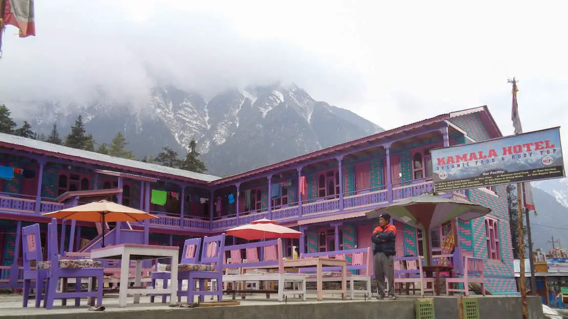
Typical mountain lodge.
To sum up, don’t expect luxury hotels, but the accommodations are absolutely decent. Of course, the higher you go, the more basic they get: the power outlets (no adapters needed) disappear from the rooms, hot showers and WiFi start to cost extra, and so on.
The food, on the other hand, is practically a constant along the whole route. The cuisine is mainly of four kinds: Nepalese, Indian, Chinese and finally some Western dishes. The menus usually have: pasta, rice or noodles stir-fried with vegetables/chicken/buffalo/eggs/cheese, boiled eggs/omelets, dal bhat (a typical local dish with rice, vegetables and lentil soup), soups (tomato, egg, potato, garlic, vegetable, chicken, noodle, etc.), pizza, pancakes, porridge, muesli, different kinds of tea, coffee and various drinks.
N.b. I recommend avoiding meat to prevent stomach issues, as the preservation methods may not always be optimal.
As you can see, there’s a fair amount of variety, but we personally often ended up eating two portions of dal bhat a day, which is by far the best dish in terms of cost/quantity, since a second helping is practically a given, and you can often keep getting your plate refilled until you burst.
As for water, some villages offer safe filling stations that guarantee water potability and are definitely a greener solution than plastic bottles. As mentioned above, I strongly recommend a LifeStraw, water filter or water bottle with filter: you save money and don’t have to rely on the filling stations.
Overview of the costs of the Everest Base Camp trek
Food
Breakfast (porridge, omelet, muesli)
At low altitude: 300 to 400 rupees.
At altitude (above 3000 to 3500m): 500 to 600 rupees.
Lunch/dinner (Fried rice, pizza, pasta, dal bhat, etc.)
At low altitude: 450 to 500 rupees.
At altitude (above 3500m): 700 to 800 rupees.
Soups
At low altitude: 200 to 250 rupees.
At altitude (above 3500m): 300 to 450 rupees.
Tea
At low altitude: 50 rupees.
At altitude (above 3500m): 120 rupees.
Water
At low altitude: 50 to 100 rupees.
At altitude (above 3500m): 200 rupees.
As mentioned several times in this guide, I strongly recommend a LifeStraw, water filter or water bottle with filter.
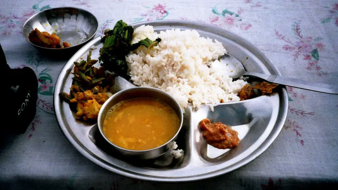
A typical plate of Dal Bhat.
Accommodation
Lodging is really cheap, often even free by consuming 2-3 meals especially if you have the will to bargain. We, for example, paid for the room only in Pangboche (250 for a double), Chukhung (500 rupees for a double), Lobuche (700 rupees for a double) and in Gorak Shep (700 rupees for a double).
Being a pair definitely gives you the upper hand when it comes to negotiating prices, but even alone at lower altitudes, you can easily sleep for free or at most pay 100-200 rupees.
There are other costs to consider, such as hot showers, WiFi, and electricity. Generally, all three become chargeable from Namche Bazar upward. We basically stopped showering (a hot shower, when available, usually costs around 500 rupees), I refused to pay 5€ to use the WiFi, and with my power bank I easily managed to charge my cell phone and camera.
Otherwise, the charging fee usually goes by the hour or by device, but especially at high altitude I wouldn’t rely on it too much: some guys in Gorak Shep told me that even though they’d left their phone charging all night, it had only charged by 10%.

The entrance to Namche Bazar.
Total cost of the Everest Base Camp trek
The cost of our trek, starting from Phaplu, including all costs (food, lodging and permits but not the visa to enter the country) and expenses incurred for two days in Kathmandu (the day before and after the trek) was 370€ each. For 20 days, about 20€ per day should be enough. In any case, I recommend having at least the equivalent of 25€ per day in cash. Expect more or less the same costs starting from Jiri (20€ per day for 23 days, so about 460€).
This is counting three meals a day but practically no extras (alcohol, soft drinks, desserts, etc.). Another thing to keep in mind is that, being two people, it’s often possible to get free lodging; the only exceptions for us were in Lobuche, Chukhung and Gorak Shep.
N.b. We had just completed the Annapurna circuit, so our itinerary didn’t include any acclimatization days (thus saving two days of food and lodging compared to the described itinerary) but on the other hand we did two variants, to Chukhung and Thame which took us two days, so to make a long story short we still spent 18 days trekking (as per the described itinerary starting from Phaplu) plus two days in Kathmandu for a total of 20 days.
Starting from Lukla, the costs rise considerably, considering that the flight alone costs around $330, and the total cost of the trek should be approximately 600€ for the planned 12-day itinerary starting from Lukla.
In any case, once the flight is paid for, food and lodging expenses are more or less the same and an average of 20€ per day should be enough. I still recommend having at least the equivalent of 25€ per day in cash.
Being able to pay by card is by no means a given, but it’s technically possible to withdraw cash in Lukla and Namche. Still, I recommend not relying on it too much and stocking up on cash in Kathmandu.
Nabil Bank allows you to withdraw up to 35000 rupees with a fee of 500 rupees, while Standard Chartered Bank allows you to withdraw up to 25000 with no fees. These are the two best options for withdrawing, depending on the card you have.
For more information on which cards to use abroad (without spending a fortune in bank fees) I strongly recommend you check out this article.

Pheriche valley.
Safety along the trails
The entire area (and Nepal more generally) is extremely safe. I never felt threatened, and the locals are extremely friendly and helpful along the whole route. The trails are well marked and well trodden, easy to follow, but as mentioned several times, you can always consult Organic Maps if you have any doubts.
The only real danger may be the altitude: especially if you decide to complete the trek, you may experience so-called mountain sickness. In fact, after reaching 3000 to 3500 meters, some people may start to experience symptoms such as lack of appetite, difficulty breathing, headache, difficulty sleeping, fatigue, vomiting, etc.
Here are four useful tips:
- The most important rule of all is to avoid overdoing it: climb at a steady pace. Ideally, climb more slowly than you feel you could sustain.
- Don’t underestimate the symptoms. As long as it’s a slight headache before going to bed and you feel fine the next day, there’s no problem, but if the symptoms persist, avoid gaining any more altitude; often, a day of acclimatization/rest is more than enough to then continue. In some cases, it’s advisable to descend a few hundred meters and, once you feel better, resume the ascent. Basically, never keep climbing if you feel sick.
- Above 3000 meters, it’s recommended never to sleep more than 500 meters higher than the previous night. To be honest, we often exceeded this recommendation without any problems; in any case, I’d limit myself to 700/800 meters at most.
- Drink lots of water. Staying hydrated is essential.
There are also some medications, such as Diamox (acetazolamide), that help prevent altitude sickness, but honestly I have no experience with them and I’m not a huge fan of medications. In my opinion, it’s better to listen to your body instead of relying on medicines: take your time acclimatizing and, if your symptoms get worse, go down to a lower altitude. Keep in mind, though, that Diamox is a prescription drug that some trekkers take as a preventive measure, so if you’re thinking about using it, talk to your doctor before you leave.
In any case, never leave without travel insurance. The only three insurers that cover this activity (as far as I know) are World Nomads, which lets you cover trekking up to 6000 meters by adding it as an extra activity, TrueTraveller, which offers coverage for trekking above 4600m when you add the “Extreme Pack”, and finally SafetyWing, which covers trekking up to 6000 meters when you add the “Adventure Sports” pack. As mentioned earlier, most other insurers stop at 3500 meters, some even lower.
N.b. In light of fraudulent practices by some local tour operators, if you really do need a helicopter evacuation, it’s important to try to contact your insurance company to arrange everything, so as to avoid disputes.
Finally, most of the supplies to the villages are carried by mules and yaks. These animals aren’t exactly graceful in their movements, so be especially careful and always keep to the inside of the trail to avoid being pushed toward the valley floor.

A mule caravan.
Where to sleep in Kathmandu
I spent two weeks in Kathmandu, trying out several accommodations, first with Dad and then on my own while waiting for my visa to India. Here are my recommendations.
Gurung’s Home – Rock-bottom prices for both the dorm and the private rooms.
The Sparkling Turtle Backpackers Hostel – Great hostel at a really good price with really nice staff. The only downside is the location: it’s about 3km from the center of Thamel, near the Monkey Temple; otherwise, it’s highly recommended.
Andes House – Clean and inexpensive private rooms right in the center of Thamel.
Hotel Triratna – Good facility slightly further from the center of Thamel, great wifi, and the single room is really cheap.
Thamel Home – Slightly more expensive than the options listed so far, but still affordable by my standards. The rooms are really nice, the wifi is great, the included breakfast is decent, the staff is definitely friendly and helpful, and the location is great.
Do you have any questions? Updated information? Don’t hesitate to leave a comment or message me on Instagram!
If you found this article helpful, please consider purchasing your travel insurance through one of the links you find on the blog to support my work at no additional cost to you. The insurance I recommend for this type of trip is TrueTraveller, which offers coverage for treks above 4600 meters when you add the “Extreme Pack” package. Alternatively, sign up for SafetyWing and add the “Adventure Sports” package which offers coverage up to 6000 meters.
For donations/pizzas and virtual beers 🙂
Did you like the post? Pin it!